![]()
SLOPE SOARING SITES OF SOUTHERN ENGLAND
SLOPES C-D
Here's information on radio control slope soaring sites (model glider flying slopes). This page lists slopes beginning with C and D. Download the pdf from the Home page if you want this information in a prettier format with more photographs.
_______________________________________________________________________
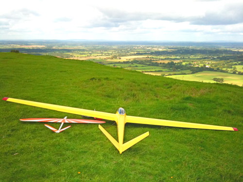
COLLEY HILL, SURREY - Wind: S
Where’s that then?
A stone’s throw outside the M25, to the south of London near Reigate. This is one of the closest slopes to London. It is also the only slope on the North Downs to rival the South Downs for lift.
So what’s it like?
Colley Hill is a good burly slope. This is another way of saying there is a lot of lift but also a fair bit of turbulence. The good news is that over the last few years the National Trust has eradicated most of the scrub from the slope, which has made the air smoother than ever before.
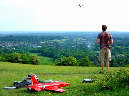
Summer soaring at Colley Hill
The slope is steeper than most and higher than most. It faces SSW at the head of a valley and so works best in SSW wind. It is also very good in south wind. It is flyable in southwest wind but often more turbulent. It does not work well if the wind is any more westerly than southwest.
Colley Hill can be a mega-lift slope when the wind is right. You know the opening scene of the seminal American slope soaring movie 'Lift Ticket'? The one with the Higgins F-20 doing high speed aerobatics in mega-lift next to the Golden Gate Bridge? That sort of flying is on the agenda at Colley Hill when the wind is over 15mph or so. Alternatively, relaxed flying can be had in wind of only 5-10mph, when the lift will be at its smoothest.
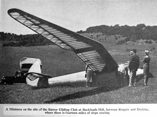
Amazingly, full size gliders were flown at Colley Hill in the 1930s and 1940s, including this Minimoa
Landing at Colley Hill can be slightly tricky: the landing area is backed by trees, and the air over the landing area is usually gusty. The best landing approach is to land sideways along the slope rather than trying to turn over the trees.
A couple of hundred yards to the right of the main slope a grassy knoll can be seen, and this is often the smartest place to fly. The air is smoother here and landing easier. Delicate floaty models can safely be flown from this knoll when the wind is light. Since the knoll protrudes from the face of the hill it works in winds from southwest around to southeast. Here's a bit of trivia knowledge: the knoll actually has a name of its own, Saddle Knob.
Between Saddle Knob and the main slope, the scrub clearance has recently revealed a good southeast facing slope. The lift is good in southeast and SSE winds, but the landing area is narrow. In southeasterlies the smart thing to do is to launch at the southeast slope and then, when it comes time to land, fly 100 yards left or right to land on a larger landing area.
Marks out of 10?
The lift is worth 7 and the landing area is worth 5, so let’s call it 6. Colley Hill is definitely the best slope so close to London.
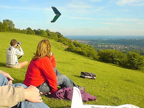
A good way for novices to enjoy Colley Hill is to bring a foamy and leave the balsa masterpiece at home
How do you get there then?
Colley Hill is a few hundred yards from Junction 8 of the M25 (Sutton/Reigate). At Junction 8, go up the A217 towards Sutton for just 100 yards and turn left into a small road called Margery Road. Drive for almost a mile to the end of the road and park in the Margery Wood carpark (National Trust members park for free, but the Trust now expects non-members to pay £4 to park at any of its carparks!) Walk along the dirt track that begins next to the National Trust information sign, through the woodland and over the M25 on a footbridge (about 200 yards in all). The slope is through the gate.
___________________________________________________________________________
A stone’s throw outside the M25, to the south of London near Reigate. This is one of the closest slopes to London. It is also the only slope on the North Downs to rival the South Downs for lift.
Colley Hill is a good burly slope. This is another way of saying there is a lot of lift but also a fair bit of turbulence. The good news is that over the last few years the National Trust has eradicated most of the scrub from the slope, which has made the air smoother than ever before.
Summer soaring at Colley Hill
Colley Hill can be a mega-lift slope when the wind is right. You know the opening scene of the seminal American slope soaring movie 'Lift Ticket'? The one with the Higgins F-20 doing high speed aerobatics in mega-lift next to the Golden Gate Bridge? That sort of flying is on the agenda at Colley Hill when the wind is over 15mph or so. Alternatively, relaxed flying can be had in wind of only 5-10mph, when the lift will be at its smoothest.
Amazingly, full size gliders were flown at Colley Hill in the 1930s and 1940s, including this Minimoa
A couple of hundred yards to the right of the main slope a grassy knoll can be seen, and this is often the smartest place to fly. The air is smoother here and landing easier. Delicate floaty models can safely be flown from this knoll when the wind is light. Since the knoll protrudes from the face of the hill it works in winds from southwest around to southeast. Here's a bit of trivia knowledge: the knoll actually has a name of its own, Saddle Knob.
Between Saddle Knob and the main slope, the scrub clearance has recently revealed a good southeast facing slope. The lift is good in southeast and SSE winds, but the landing area is narrow. In southeasterlies the smart thing to do is to launch at the southeast slope and then, when it comes time to land, fly 100 yards left or right to land on a larger landing area.
The lift is worth 7 and the landing area is worth 5, so let’s call it 6. Colley Hill is definitely the best slope so close to London.
A good way for novices to enjoy Colley Hill is to bring a foamy and leave the balsa masterpiece at home
Colley Hill is a few hundred yards from Junction 8 of the M25 (Sutton/Reigate). At Junction 8, go up the A217 towards Sutton for just 100 yards and turn left into a small road called Margery Road. Drive for almost a mile to the end of the road and park in the Margery Wood carpark (National Trust members park for free, but the Trust now expects non-members to pay £4 to park at any of its carparks!) Walk along the dirt track that begins next to the National Trust information sign, through the woodland and over the M25 on a footbridge (about 200 yards in all). The slope is through the gate.
DEVIL’S DYKE, WEST SUSSEX - Winds: NW, N
Where’s that then?
Just outside Brighton.
So what’s it like?
Devil’s Dyke is a popular slope soaring and paragliding location due to its ease of access and proximity to Brighton. The main slope is a large, steep bowl that faces NNW. It is an impressive 150 metres high. It features superb lift in northwest to north winds. The lift can be smooth - or it can be turbulent if the wind isn't straight onto the slope.
This 4-metre scale glider is hard to tell apart from the full size gliders that soar over Devil's Dyke
The landing area is reasonable but not huge. Take care not to fly too far back, because nasty turbulence lurks behind the flat area. At weekends there can be walkers and kite flyers obstructing the landing area. Paragliders and radio control planes each have their own separate air space so paragliders are not a problem (but if paragliders ever stray into the model flying area, give them right of way).
The carpark is right on the slope so access is particularly easy. For the best soaring spot, park in the furthest carpark and walk about 50 yards east. Do not fly directly in front of the Devil's Dyke pub because paragliders fly there. The pub serves food and drink all day and there is usually an ice cream van in attendance. So this is not one of those locations where you need to rough it!
When the wind is low, normal (non-glider) electric powered model planes are flown here. Soaring Devil’s Dyke can be good fun due to the impressive slope and the carnival atmosphere.
Little and large
If Devil’s Dyke turns out to be too crowded for your taste, you could consider flying nearby at Jack and Jill Hill or Ditchling Beacon, which work in north winds and are usually far more peaceful. They are just on the other side of the A23. The National Trust even produces a map for walking there: Dyke to Ditchling Trek. Here’s an idea: drop the family at Devil’s Dyke and send them on the walk. Fly at the Dyke for a while. Drive over to Ditchling Beacon. Fly there for a while. Collect the family when they arrive. Everybody’s happy. You never know, it could work!
Marks out of 10?
Devil’s Dyke scores 7 (the slope itself is possibly worth 8 but a point is deducted for crowding).
How do you get there then?
If you’re starting from the London area, drive down the M23. Pass Gatwick and keep going as the M23 becomes the A23. When you reach the A27, just outside Brighton, get into the left lane to turn west along the A27 towards Worthing - but don’t floor it, because you need to exit at the next junction which is less than a mile along the A27. This is the B2121 and is clearly marked Devil’s Dyke.
Go north up this road. Continue straight up this road for about 3 miles all the way to the top (you’ll pass a couple of roads that curve off to the right but do not be tempted by these). Park in the carpark (£2 except for members of the National Trust) and you can virtually launch your plane from the car. The pub’s postcode is BN1 8YL.
(By the way, at night Devil’s Dyke has a bit of a reputation for alfresco sex, so make sure you leave in good time … or stay behind, as is your wont.)
____________________________________________________________________________
DITCHLING BEACON, EAST SUSSEX - Wind: NE
Where’s that then?
Can you count the fingers on one hand? That’s how many miles north of Brighton this is, a few miles off the main London to Brighton road (the M23/A23).
So what’s it like?
Pretty great! The slope is about 150 metres high and is steeper than ... well, an unsteep slope. The main slope is a large bowl that faces NNE. It works in north to northeast winds. If it gets any more easterly than northeast, it stops working well because to the right is a hill blocking the wind. The lift is strong, but for some reason there is often turbulence. The landing area is a little narrow but perfectly okay – although there is the odd barbed wire fence if you’re really determined to test the survivability of your pride and joy. It’s probably best to launch and land from the flat top of the slope. Some flyers climb over the fence to stand on the slope itself, but the landing is rather restricted there. If the wind is from the north, the best flying will be at the far end of the slope (about three hundred yards east of the carpark) whereas if the wind is more northeast the area closer to the carpark will be more directly into the wind.
![]()
Big air, big turbulence ... a man's slope
Ditchling Beacon is public access land owned by the National Trust. There are also other possible slopes both ways along this ridge if you can bear the thought of walking. A couple of hundred yards west of the carpark is a north facing slope that is almost as good as the main slope. It is possible to soar along the various bowls to Jack and Jill Hill, two miles west. From the main slope, it is also possible to continue flying eastwards for several miles.
Three miles east of the carpark is Plumpton Hill, a bowl that produces big lift in north to northeast winds - just like Ditchling Beacon - but seems to have slightly smoother air. The reason Plumpton Hill is not used by flyers is that the access track is almost too rough for vehicles. It is probably best to tackle the track on foot, or hike from Ditchling Beacon. The land at the top is working farmland owned by the National Trust so be careful not to flatten crops or anything like that.
If hiking is your thing, visible from Plumpton Hill is Kingston Castle Hill. This orchid nature reserve has no vehicular access but rewards the keen hiker with a good northeast bowl and various other northerly flying spots. Information on the reserve is available from Natural England. Care needs to be taken not to trample the rare wildflowers and butterflies.
Overall Ditchling Beacon has great lift and a reasonable landing area – although sometimes the turbulence provides a bit too much excitement! If it is too gusty for your taste, you could always drive around to the milder slope at Jack and Jill Hill.
If you want to send your family off on walks while you fly, there is a downloadable brochure of walks in the area: Ditchling Walks.
![]()
The bowl is steep despite how it looks
Marks out of ten?
Ditchling Beacon earns 7. It’s a darned good slope. It’s not hugely popular – Bopeep Hill attracts more flyers in northeast winds – but it usually has one or two flyers on it when conditions are right. Plumpton Hill and Kingston Castle Hill would merit similar scores except that access is a bit challenging.
How do you get there then?
Follow the directions to Jack and Jill Hill, except don’t turn into Mill Lane. Continue on up the A273 for half a mile and just before the road to Ditchling village turn right along the small road to Clayton (Underhill Lane). Eventually you reach a crossroads with a somewhat larger road: turn right up this road. It is signposted 'The Beacon'. The road rises steeply to the National Trust carpark at the crest of the hill on your right - you’ll see the sign just too late to turn into it. Park in the carpark and walk east across the road - the slope is right there. The other smaller slope is several hundred yards west of the carpark. The air at this smaller slope can be smoother if the main slope is too gusty.
Plumpton Hill is accessed either by hiking from Ditchling Beacon, or on foot up the public track that begins opposite Plumpton Lane.
Kingston Castle Hill is accessible from the carpark on Falmer Road (the B2123) or from Kingston near Lewes.
Ditchling Beacon Map
Plumpton Hill Map
Kingston Castle Hill Map
____________________________________________________________________________